Loch Katrine
|
Stob a' Choin |
|
| |
|
date climbed |
7/9/2022 |
time taken |
3 hours |
|
distance |
8km |
ascent |
600m |
|
OS Map |
OS 56 |
Weather |
Good visibility |
|
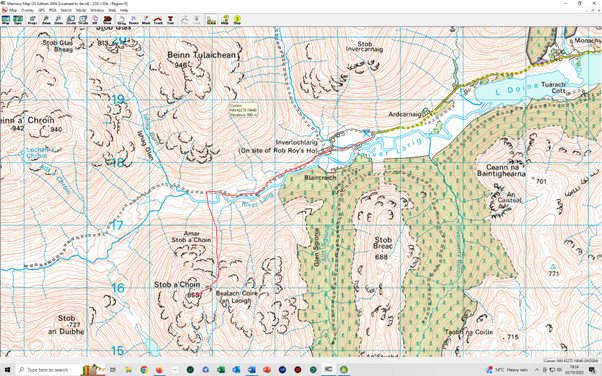
Starting point : Ardcarnaig, West of Loch Voil | |||
|
Stob a' Choin is an impressively steep and rugged mountain as seen from Inverlochlarig, yielding nothing to its higher neighbours. Its ascent gives a rough walk the reward is a stunning view from a fine summit. There is a car park on the left at the end of the bumpy public road up past Loch
Voil. Begin the walk by following the track which is the continuation of the road,
passing Inverlochlarig - Continue along the track until a footbridge over the river. Cross this to reach very boggy ground on the opposite side. Aim southwest, climbing diagonally across the hillside. The north ridge of Stob a' Choin is blocked by crags, so the aim is to reach it by crossing steep grassy ground above the difficulties. A fence across the hillside at around 400m is crossed by means of a gate a couple of hundred metres each of the burn flowing down from the Bealach Coire an Laoigh. This burn is in a deep ravine at this point, so aim briefly left to get above some crags before returning to reach the burn at 470m where it is easy to cross between two sections of ravine. On the far side climb steeply to gain the upper grassy rake originally seen on the approach. The going is steep and rough to eventually gain the grassy north ridge. Turn up this ridge towards the summit. There are stunning views back, especially looking along Loch Voil. After a final very steep pull up grass the tiny cairn of the north summit is gained. Return the same route. |
|
Beinn Stacath |
|
|
|
|
|
date climbed |
7/9/2022 |
time taken |
3 hours |
|
|
distance |
10km |
ascent |
600m |
|
|
OS Map |
OS 57 |
Weather |
Good visibility |
|
|
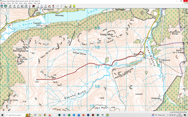
Starting point :Glen Buckie |
| |||
|
Beinn Stacath may be in the heart of the Trossachs, but few hillwalkers have heard
of it. Its grassy summit is unnamed on OS maps, it has also been known as Stob Fear- There is enough space to park several cars at the end of the public road up Glen Buckie, just above Ballimore. Cross the bridge over the burn and then turn immediately right up the steep bank at the sign for the right of way to Brig o'Turk via Glen Finglas. Follow a faint path southwest across the field crossing a dip and a small burn. Head for the farm gate in the wall ahead. The gate has a sign for the path to Brig O'Turk and should be climbed before continuing on the rough path ahead. The path is very wet in places and keeps above the burn on the right but does not climb to the higher ground on the hillside. When the path turns southwards beyond Sròn a Chonnaidh leave it to cross a gate in the fence ahead, then continue west over tussocky ground to reach and ford the river. In spate conditions, there are bridges upstream which would add a kilometre or so to the walk. Once over the burn, continue aiming west across the boggy flats to begin the climb up the featureless east ridge of Beinn Stacath. The going is mostly rough grass and tussocks, with the reward being in the improving views to either side. Follow the indeterminate ridge over several hummocks and bumps, crossing the Bealach Stacach before reaching a small rocky outcrop and a lochan, with views to Ben Lomond. From the lochan lines of fenceposts lead to the trig point which marks the summit of Beinn Stacath. Return the same way as the ascent. |
|
Benvane |
|
| |
|
Ben Ledi |
| ||
|
date climbed |
6/9/2023 |
time taken |
7 hours |
|
distance |
16km |
ascent |
800m |
|
OS Map |
OS 57 |
Weather |
Poor visibilty and some rain |
|
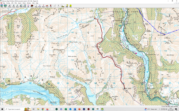
Starting point :Glen Buckie | |||
|
Benvane is the lesser known northern neighbour of Ben Ledi. Its eastern flanks above Loch Lubnaig are densely forested. Ben Ledi is a familiar landmark from Callander and the highest mountain in the main part of the Trossachs. It is a very popular hillwalk and its position on the edge of the Highlands makes it an excellent viewpoint. The two Corbetts were done as one expedition. Start at the car park at the end of the public road up Glen Buckie, just above Ballimore. From here walk over the old stone bridge, onto land belonging to Immeroin Farm, and then immediately up the steep bank on the right to follow a faint path southwest across the field crossing a dip and a small stream. Head for the farm gate in the wall ahead. The gate has a sign for the path to Brig O'Turk and should be climbed before continuing on the rough path ahead. Almost immediately after the gate, the path splits - The climb is gentle and straightforward on short grass with a few boggy patches that
are easily by- The ridge was then followed to the ascent of Ben Ledi with no difficulties. Return the way of the ascent. |