Mullardoch Circuit

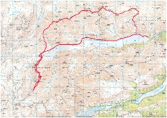
The aim of my first Munro bagging trip to Scotland in 2011 was the area of the Glen Cannich that encircles Loch Mullardoch. There are twelve Munros on the circuit and it was hoped to complete them all over a 2 day backpacking trip using Steven Fallon's route description as a guide.
|
Carn nan Gobhar |
992m/3225ft |
|
|
|
Sgurr Lapaich |
1150m/3773ft |
| |
|
An Riabhachan |
1129m/3704ft |
| |
|
An Socach (Cannich) |
1069m/3507ft |
| |
|
Mullach na Dheiragain |
982m/3222ft |
| |
|
|
|
|
|
|
date climbed |
13/05/2011 |
time taken |
14 hours |
|
distance |
32 miles |
ascent |
16500ft |
|
OS Map |
Landranger 25 |
Weather |
Very strong gusts of wind, hail, snow, mist in showers |
|
Starting point : Mullardoch Dam - | |||

After the long drive from York, the MWIS weather was checked -
The stalkers path was followed from the Dam up the East bank of the Alt Mullardoch
and into Corire an t-
|
Sgurr nan Ceathreamhnan |
1151m |
| |
|
An Socach |
921m | ||
|
Mam Sodhail |
1181m | ||
|
Beinn Fhionnlaidh |
1005m | ||
|
Carn Eighe |
1183m | ||
|
Tom a'Choinnich |
1112m | ||
|
|
|
|
|
|
date climbed |
21/06/2011 |
time taken |
15 hours |
|
distance |
30 miles |
ascent |
12 600ft |
|
OS Map |
Landranger 25 |
Weather extremely misty, some rain | |
|
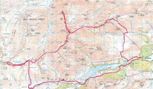
Starting point : Glen Affric - | |||

Back to the Glen Affric and Mullardoch area in June after the aborted attempt at the whole Mullardoch circuit in May. This time the mountains were approached from the south via a night in the wonderful, remote youth hostal at Alltbeithe in Glen Affric. After the drive from the south, the car was left in the Glen Affric car park. The three hour walk in through Glen Affric was wonderful and gave time to admire the wonderful Caledonian pines in the lower reaches of the Glen. I was joined at the hostal by a group of German walkers who very kindly shared their meal of pasta and pesto with me.
The day started with reasonable weather and visibility. The path to the col between Sgurr nan Ceathreamhnan and An Socach was picked up at the hostal and followed all the way to the belach. Turning left at the belach, the ascent of Sgurr nan Ceathreamhnan was uneventful but the visibility had closed in before I reached the summit so it was not possible to see the view from what is considered one of the great hills of the Western Highlands. The ascent route from the belach was then reversed and the series of ascents of the other peaks started. I was feeling that luck was certainly not on my side with the Scottish weather since the mist thickened even further and maintained its hold on the mountains for the rest of the day complemented with heavy showers of rain. Navigation on the wide hogs back ridges of Mam Sodhail and its neighbours kept me on my toes all the day making sure no mistakes were made on the traverse. The crux of this was probably the "there and back" section north of Carn Eige along the sinous limb to Beinn Fhionnlaidh which proudly sits above Loch Mullardoch. The weather at this point was particularly horrible. Progress was slower than anticipated with the level of navigation required so when Tom a'Choinnich's summit was reached it was time to make tracks back to Glen Affric rather than carry on to the last Munro on the circuit, Toll Creagach. So the magnificent views from the summits of Kintail and beyond will have to wait to my second round of Munros.
|
Toll Creagach |
1054m/3458ft |
| |
|
date climbed |
22/06/2011 |
time taken |
5 hours |
|
distance |
7.5 miles |
ascent |
3400ft |
|
OS Map |
Landranger 25 |
Weather extremely misty, some rain | |
|
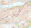
Starting point : Mullardoch Dam - | |||

After an aborted attempt to drive up Strathfarrar due to the entrance gate being closed on Wednesday mornings, the revised plan of the day was to finish off the last Munro of the Mullardoch circuit, Toll Creagach. The Dam at Mullardoch was the start point of the walk and Steven Fallon's descent route reversed to the top of the summit. Weather again was pretty bad but I did not feel it was a wasted day having now completed the twelve Munros on the Mullardoch circuit.